Directions
to the
Annual Purple Martin Field Day in Louisa, VA
NOTE: BRIDGE CLOSED!
This event is held at an unpublished address of a private farm along Hamilton Rd. (Rte. 695) in Louisa County, VA. If your route would bring you to Hamilton Rd. from its east end, that road is now impassable, because the Hamilton Rd. bridge over the South Anna River is unsafe and has been CLOSED!
Even if the bridge closure will not affect your trip, the simplest way to plan your route (and know the travel time it will require) is to obtain the street address of the farm. To do this, please call the Purple Martin Field Day contact person, Kathy, NOW, at (434) 222-1831 and leave a voicemail asking for the address of the farm. OR … you may send a text to that number, asking for the farm address. Within 1-2 days, an individual text message will be sent to the phone number from which you called or texted; it will contain the street address, which you can copy/paste into one of the navigation apps listed below. If you do not have a smartphone or cannot receive lengthy texts and need to receive a return phone call, instead of a text…call Kathy at the above number, leave a voicemail, and in that voicemail, please ask for a phone call to receive the farm address; you will be called back within 1-2 days. If you reach out to us by either method, please add our PMFD number to your Contacts list so our callback will not be blocked, and so you will recognize/answer our call (or read our text) when we get back with you…and won't report us as "junk" or "spam!"☺
For privacy reasons, we do not post on the internet the address of this private dwelling, and we ask that you not post the address we share with you, online or on any social media.
Some navigation apps/websites are aware of this bridge closure and are showing alternate/detour routes—BUT some apps are NOT! Therefore, after you receive the farm address from us, we recommend you use one of THESE mapping/navigation apps or websites to see your route:
- Google Maps
- Apple Maps
- Waze
We believe these resources are aware of the bridge closure and will show alternate routes, so you can find an accurate route and see how long it will take you to get to the farm.
Please contact us NOW to request the farm address. If you do not call/text the Purple Martin Field Day contact phone number to ask for the address to plan your route BEFORE the day of the event, we may not be able to provide the address, or help you with directions, since we will be very busy, setting up for the event. We also cannot guarantee cell phone reception at the farm, so your call may not go thru to reach us. So please call or text NOW, to receive the address, if you plan to attend, or think you might be able to come.
If you have joined us in the past, please check your route using one of the above-listed apps, to see if your route has been changed, since either of the detours will require 15-20 minutes longer than your previous travel time.
If you are coming from the north, south, or west, and you arrive at the "intersection of E. Jack Jouett Rd. and James Madison Hwy" highlighted in yellow, below, your route from that point will not involve any detours.
Our apologies … but this is beyond our control.
WE DO NOT WANT ANYONE TO GET LOST, AND WE DO NOT WANT YOU TO MISS THE DOOR PRIZE DRAWING WHICH HAPPENS NEAR THE BEGINNING OF THE EVENT, WHICH STARTS AT 11:00A.M.!
Go to the "intersection of E. Jack Jouett Rd. and James Madison Hwy" (James Madison Hwy=Rte. 15) (CLICK HERE)
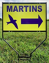
From there, follow the MARTINS signs to the event site, allowing 15 more minutes to reach the private farm.
Or, use these GPS coordinates:
38.024805,-78.190525
(or)
38°01'29.3"N 78°11'25.9"W
From there, follow the MARTINS signs to the event site, allowing 15 more minutes to reach the private farm.
From Richmond, VA: Follow I-64 West toward Charlottesville; take Exit 136 (Zion Crossroads); turn right onto Rte. 15 North; from the LOWE’S/WAL-MART traffic light, go 3.4 miles on Rte. 15 North; turn right onto E. Jack Jouett Rd. (Rte. 640) and follow the MARTINS signs to the Field Day site (allowing 15 more minutes to reach the private farm).
From Orange, VA: Follow Rte. 15 South to Boswells Tavern; go about 3 miles on Rte. 15 South; turn left (east) on E. Jack Jouett Rd. (Rte. 640) and follow the MARTINS signs to the Field Day site (allowing 15 more minutes to reach the private farm).
From Louisa, VA: New alternate route: Follow Rte. 22 West/33 West (W. Main St./Louisa Rd.) out of Louisa. Turn left on Rte. 638 (Nolting Rd.) Bear left on E. Jack Jouett Rd. (Rte. 640.) Turn left on Rte. 695 (Hamilton Rd.) and follow the MARTINS signs to the Field Day site. Please read the red NOTE, above!
If your route involves coming through Louisa, VA or traveling on Poindexter Rd. (Rte. 613)… reaching the farm from the eastern end of Hamilton Rd. (Rte. 695) is not possible, because the bridge on Hamilton Rd. that crosses over the South Anna River is unsafe and is CLOSED! If your route would have brought you to Hamilton Rd. (Rte. 695) from east of the South Anna River, you will need to use the alternate route, above. We suggest you contact us at the phone number above, to receive the farm address, so you can view your route and travel time on the recommended navigation apps/websites listed above.From South Boston, VA: Follow 360 East to Keysville, then take Rte. 15 North to Farmville; follow signs (making turns) to stay on Rte. 15 North; cross I-64 at Zion Crossroads; from the LOWE’S/WAL-MART traffic light, go 3.4 miles on Rte. 15 North; turn right onto E. Jack Jouett Rd. (Rte. 640) and follow the MARTINS signs to the Field Day site (allowing 15 more minutes to reach the private farm).
From Charlottesville, VA: Follow I-64 East and take Exit 136 (Zion Crossroads); bear left onto Rte. 15 North; from the LOWE’S/WAL-MART traffic light, go 3.4 miles on Rte. 15 North; turn right onto E. Jack Jouett Rd. (Rte. 640) and follow the MARTINS signs to the Field Day site (allowing 15 more minutes to reach the private farm).